
Frequency-modulated continuous-wave (FMCW) ice radar has the advantages of small size, light weight, low power consumption, and high range resolution. It can be mounted on various aircraft and snowmobiles to enable fine detection of layered features in polar ice bodies. It is widely used in studies of snow accumulation processes and evolution in ice sheets, as well as sea ice thickness and sea-ice-atmosphere interactions, providing an important technical method for revealing changes in polar ice sheets and sea ice. At present, FMCW ice radar imaging methods are generally divided into time-domain and frequency-domain approaches. Time-domain methods mainly use the backprojection algorithm, which can directly compensate for platform motion errors in the time domain, but it involves heavy computation and low processing efficiency. Frequency-domain methods use the fast Fourier transform (FFT) to convert complex time-domain operations into efficient frequency-domain multiplications, significantly reducing computational complexity and fundamentally overcoming the low efficiency of time-domain algorithms, making them the mainstream choice for FMCW ice radar data imaging. The ω-K algorithm and the frequency scaling algorithm are two representative frequency-domain methods. The ω-K algorithm can theoretically achieve extremely high imaging accuracy because it does not introduce approximations in signal processing; however, it requires Stolt interpolation for accurate range cell migration (RCM) correction, which is computationally expensive and significantly limits imaging speed. The frequency scaling algorithm compensates for range cell migration by introducing a frequency scaling transformation function, avoiding time-consuming Stolt interpolation and thus improving imaging speed; however, it does so at the cost of introducing certain approximations, resulting in slightly lower imaging accuracy than the ω-K algorithm. Because FMCW ice radar generates extremely large amounts of data, even more efficient frequency-domain algorithms still face an irreconcilable trade-off between speed and accuracy, or a processing bottleneck. Therefore, in practical applications, it is necessary to seek and adopt more efficient focusing and imaging techniques to further reduce the heavy computational burden caused by massive data.
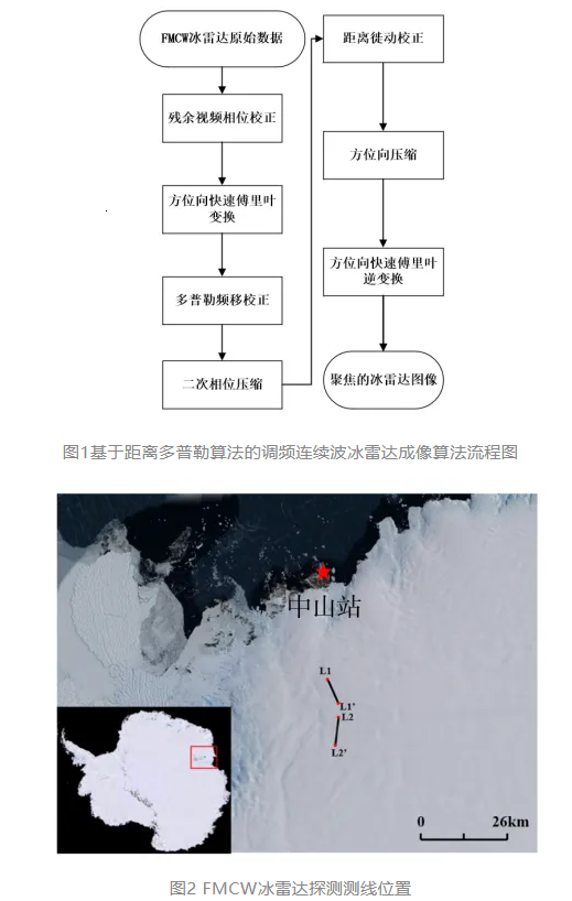
Recently, the Polar Research Institute of China (also known as the Polar Center), together with the Institute of Polar Snow and Climate Change Research, Beijing University of Technology, and the Aerospace Information Research Institute of the Chinese Academy of Sciences, proposed for the first time a range-Doppler algorithm suitable for FMCW ice radar data imaging and processing. Through range cell migration correction and secondary range compression, the algorithm achieves imaging accuracy comparable to that of the frequency scaling algorithm while significantly improving computational speed and image signal-to-noise ratio. The range-Doppler imaging algorithm mainly consists of the following steps (Figure 1): 1) azimuth fast Fourier transform; 2) residual video phase correction; 3) Doppler shift correction; 4) secondary range phase compression; 5) range cell migration correction; 6) azimuth compression; and 7) azimuth inverse fast Fourier transform.
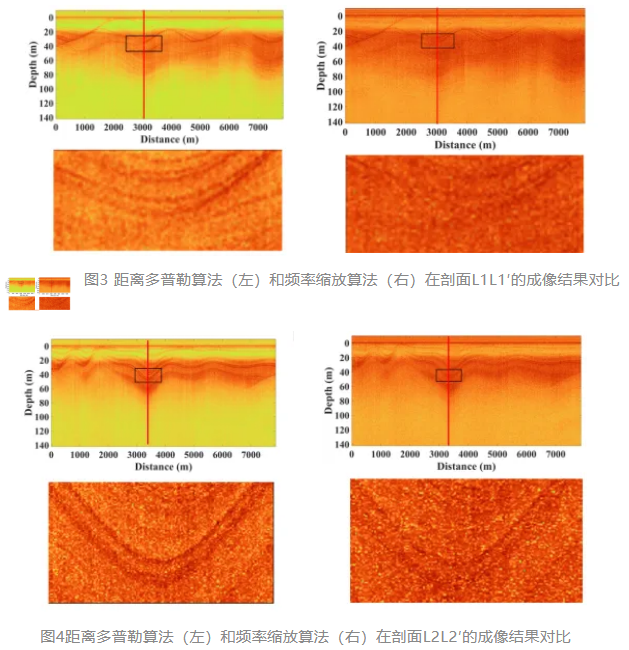
The research team used FMCW ice radar measurement data collected during China’s 33rd Antarctic scientific expedition (2016/17) to verify the practical performance of the range-Doppler algorithm in FMCW ice radar imaging and compared it with the frequency scaling algorithm. The ice radar data profiles L1L1′ and L2L2′ are both located in the ice sheet margin area near Zhongshan Station, as shown in Figure 2. Figures 3 and 4 show the comparison of imaging results for profiles L1L1′ and L2L2′ using the range-Doppler algorithm and the frequency scaling algorithm, respectively. Experiments showed that the processing time of the range-Doppler algorithm for Figures 3 and 4 was 471.85 seconds and 508.93 seconds, while the frequency scaling algorithm took 597.41 seconds and 647.01 seconds for the same figures. This means the range-Doppler algorithm improved processing speed by 21.01% and 21.34%. In addition, the imaging results show that, compared with the frequency scaling algorithm, the ice radar data processed by the range-Doppler algorithm produced clearer internal reflection interfaces in the ice sheet, and the signal-to-noise ratio of the single-channel ice radar data at the red-line position was higher (new method: 25.60 dB and 28.97 dB; frequency scaling algorithm: 20.52 dB and 23.54 dB), better suppressing noise during imaging. Therefore, the new method will further improve the efficiency of on-site processing and quality control of FMCW ice radar observation data, while enhancing the accuracy and precision of ice-layer interface extraction, thereby supporting frontier scientific research on snow accumulation processes and evolution in ice sheets, sea ice thickness, and sea-ice-atmosphere interactions.
The research results were published online in IEEE Transactions on Geoscience and Remote Sensing, a top journal in geoscience and remote sensing. The corresponding author is Researcher Cui Xiangbin from the Polar Center, and the first author is Professor Lang Shinan from the School of Information Science and Technology, Beijing University of Technology. In addition, several researchers from Beijing University of Technology, the Aerospace Information Research Institute of the Chinese Academy of Sciences, and the Polar Center participated in the study. The research was supported by the National Key R&D Program of China (2024YFB3908003) and the National Natural Science Foundation of China (42376253).
Related paper:
S. Lang, M. Xia, X. Cui*, Y. Liu, J. Zhu, J. Guo, L. Li, and X. Liu, FMCW ice sounding radar imaging based on the improved range-Doppler algorithm, IEEE Trans. Geosci. Remote Sens., vol. 63, pp. 1-9, 2025, doi: 10.1109/TGRS.2025.3564358.
Source:
China Polar Research Center (Polar Research Institute of China)